Below are some questions and concerns, in italics, that were shared in the Comprehensive Trail Plan survey. Our answers are in normal text.
_________________________________
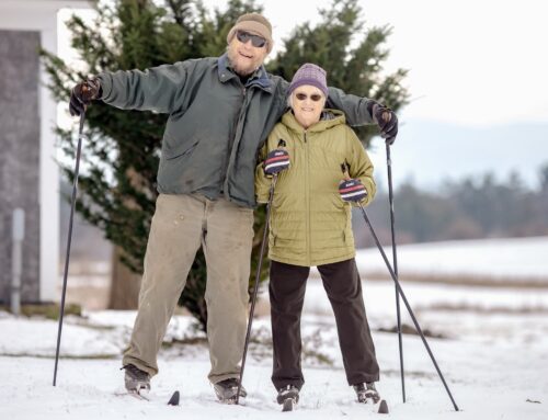
Does this eliminate the lower loop of the lit night xc skiing area? What are the plans to replace that opportunity for night skiing? Definitely one of the main reasons I have a winter xc ski membership to Catamount…
There seems to be a lack of double track connection from the hub to the other double track trails on the north side? Is this not an important XC skiing connector? Is this because of easement or private land?
Including additional detail regarding winter plans (groomed xc, ungroomed xc, fat bike, snowshoe) into the plan would help me better understand the impact on xc skiing (both skate & classic) which is my primary interest in the Catamount property.
Most of the Lower Night loop and Getting Started are on private land with unprotected access. As long as permission is granted for use, we will try to keep these trails and the lower lighted loop running. Major maintenance and upgrades are not possible and an easement is not likely here. The permitting needs to account for this.
The lighting system is fragile too, with much of the infrastructure installed in the late 1970’s and early 80’s. The cost of replacing the system is a major concern and this work can not be done on private land without protected access.
In the Comprehensive Trail Plan, we propose a way to keep a portion of Lower Night and extend it to the Powerline to connect to the upper Night Loop. The upper Night Loop is on CCF property, but the electric source is not. We are working to protect this infrastructure.
We plan to groom for skiing, fat biking and snowshoeing as much as possible when it snows. As conditions allow, groomed xc skiing is currently planned for the normal Goose Hill field loops, Elbow, Woods Trace, Sandmans, Post Rd, Night, Cabin Run, Three Rivers, Geronimo and Lookout.
One of the proposed trail improvements is drainage, which should allow for better grooming possibilities, increased snow durability and less ice.
Replacing steep sections on trails like Lookout will also increase the grooming potential and improve access to more skiers. Currently, only a handful of skiers make it to the Lookout each season.
Our goal for improved navigation and reduced intersections will make the fat bike and snowshoe loops cross the wider ski trails directly, reducing confusing co-location of these uses.
The chances of xc skiing and snowshoeing at Catamount are likely to decline going forward. One of our biggest financial challenges is to replace this vital, but shrinking revenue.
Fat biking is unlikely to replace xc skiing, although we will continue to work towards growing this segment of the community. Improved trails will also help in this area.
With free pedestrian access, walkers, hikers and snowshoers have been largely unwilling to support the Catamount Outdoor Family Center’s work, despite directly benefiting from our consistent trail work efforts, programming and events.
There is a further misconception that we are financially supported by the Town of Williston, leading to a false sense of entitlement for some users. The Catamount Outdoor Family Center does not receive operational support from Williston and has a lease with the TOW to steward and use the trails in the CCF.
We are a separate non-profit organization, and lease our indoor space and trail access in and around the Governor Chittenden homestead from the McCulloughs. This includes leasing the popular road access from Gov Chittenden Rd to Goose Hill, and the bike wash and water stations. We are also required to pay for port-a-lets for public use, despite not receiving support for this expense.
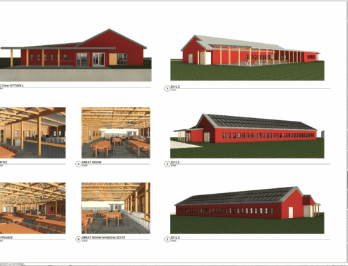
Concurrent with the trail project, we are also planning a new building on CCF-TOW land. These two projects are vital to the long term viability of the COFC, the trail network and our programs and events.
__________________
Why remove the doubleblack jump lines? That is one feature that is not available at other ‘competing’ free trail networks.
We are not removing them, we just changed the rating to better reflect the difficulty. The current lines will continue to be refined, but the difficulty levels should remain similar. We also plan to add a gentler line adjacent to the two existing lines. Further, we are excited for a much longer feature area under the Powerlines.
__________________
What does “securing a long term solution for the Lookout viewshed” mean? What is Vigneau land?
The current Lookout view cut area is not entirely on CCF-TOW land. Without permission from the adjacent landowners, which is unlikely to occur, the Lookout view will overgrow in a few years. We have identified a similar view that is contained on CCF-TOW land.
The Vigneaus own parts of Cabin Run, Gravy Train, Pop’s, Pop’s Drops and Pops Connector. They also own the power access to the upper Night Loop lights. The access to these trails and power source are not currently protected.
__________________
My biggest complaint in recent years is the fence around the parking lot. It’s a huge hinderance to parents of small children who just want to get from the parking lot to the pump track as quickly as possible. The best part of Catamount when my children were learning to ride was pulling straight into the parking lot, pulling out the bikes and sending the kids off to ride.
With a large percentage of visitors ignoring our requests to pay for bike/ski access, sign in and sign the yearly waiver, not to mention going by the maps to learn the trails, we need to funnel people past the Hub. The fence is the only way to ensure this. Even with the fence, we have people who ignore it and climb over or through, often getting stuck or lost.
We appreciate the easy access to the pumptrack and the small one still is currently open out of the parking lot. Going around to the bigger one takes a minute or two at most.
__________________
Goal 6 is unclear – are you reducing maintenance or the impact on the environment?
Our plan to accomplish both at the same time. Better built trails reduce impacts on the environment and are easier to maintain.
__________________
This plan is not Vermont-like. Vermont is strong in leaving nature alone and residents like nature in the rough vs. nature in “Disney land.” What you propose would be hugely disruptive to both nature and those wishing to enjoy nature. It will also come with a huge cost that could be better served by constructing an eco conscious small lodge for people to meet, warm up and provide access to bathrooms.
This land has been kept untamed as much as possible making it the most ecofriendly as possible. I care that this land stay in its natural state and humans adapt to it. What I see will destroy the land and destroy my enjoyment of it. I love roots, rocks and steep trails. I love the many trails and the wide variety! I love the present diversity of use. Adaptive bikes can use enough of the trails. The trails are open year round…4 seasons.
The land that is now the Catamount Community Forest has seen many changes. Within the last 80 years, it has;
- Been clearcut, bulldozed and majorly reshaped for farming, livestock, logging, mowing, housing, an internationally significant powerline corridor and recreational uses
- Had some of its wetlands drained
- Had garbage dumped on the land, much of which is still there
- Hosted events with thousands of people, including the highly impactful Haunted Forest era
- An ongoing logging/forestry component and invasive species management with herbicides that are managed by the TOW, a 100+’ wide VELCO powerline that is cleared with chemical herbicides, forestry mulchers, chainsaws and brushcutters and extensive mandated mowing on both sides of the network by TOW contracted farmers and COFC contractors and staff
We are not removing all the roots or rocks, nor destroying the land. Several steep trails on appropriate surfaces will still be part of the network, including Bear, Coyote, Off The Wall, and Mad Max with a significant extension. Rocks are planned to be a major feature of as many trails as possible.
As part of a public access forest, we believe that excluding visitors is counter-productive and selfish. Adaptive visitors do not have enough access yet and including them does not exclude anyone else.
Many of our trails like Elbow, Balsams, Geronimo, Skidway, Night, Southeast Connector, Sheep and Blackberry, North-South, Three Rivers, Clover’s Rollers and Trout Lily are closed for significant portions of the year due to poor drainage, overly steep pitches and non-durable surfaces. These trails are negatively impacting the land around them and also not available for use.
We realize that the use of the “eliminate” in regards to the proposed changes is confusing. A better word would be “replace.” The overarching easement held by the VT Land Trust and the VT Housing and Conservation Board governs what can happen on CCF property. It states that adjustment to the network is allowed, but that significant growth or shrinkage of the trails is not possible.
There are trade offs in the planning, with steeper pitches replaced by gentler stretches and some unmaintainable or inappropriate sections on trails like Skidway and Powerline A-Line set to be entirely relocated.
As these plans need permission from the Town of Williston and permits from the State of VT, with reviews by the VT Land Trust and the original funders like the USFS and the Land and Water Conservation Fund, we need to follow best practice standards for design, build and long term stewardship. These standards are in included in the plan and address deficiencies and challenges in the existing network.
Beyond the standards are the on-the-ground implementation and we are committed to beautiful, low impact, fun, character-rich reroutes, refreshes and rebuilds.
With regards to a new building, we are also planning a facility that will replace our indoor space in the McCullough’s house, the Hub, the rental barn and our storage areas. Indoor plumbing is planned, but will be limited. As mandated by the TOW, COFC currently spends ~$8k a year to supply port-a-lets for free to the public, with no support from the Town or pedestrian users.
________________________
I consider myself to be an intermediate to advanced rider. I ride 4 to 6 days a week. I only ride at COFC during the week when I am short on time or looking for a change. The main reason for this is lack of challenging trails, I see COFC as good for a work out, but not a really fun place to ride. Fixing up the jump line & slalom course would be a great attraction. On the other hand it is a great place for fatbiking!
I support COFC evolving with the times and addressing the needs of the community. We need more accessible bike trails to help people ease into the sport. It would be great if dogs were allowed, even if it was just certain days or hours.
Thank you all your hard work!
Thank you for the votes of confidence and understanding of the dynamics involved.
The statement that Catamount is “not a really fun place to ride” is a common refrain and one that we see daily evidence of in decreasing visits and revenue. There are several free-to-access trail networks near COFC that are better and more fun for most people.
While many of us are dog owners too, the CCF no dog policy is set by the Town of Williston and changes to it are not part of this trail planning project.
_______________________
I’ve been lucky enough to enjoy Catamount trails for many years and now my son is getting to do the same. COFC is an incredible community resource that will benefit from most of the actions laid out in this proposal. Perhaps somewhat selfishly, I think the trail network would benefit from more single-direction trails and fewer multi-direction ones. Multi-direction trails, particularly combined with the number of intersections, tight corners, grade reversals, and short sightlines on Catamount singletrack, can increase the potential for user conflict. Increasing network flow through simplification, better signage, and making some trails single-direction would likely lead to a more enjoyable experience. Also, the maps were difficult to read and analyze. I’d be happy to throw my GIS hat into the volunteer ring if you need assistance with mapping or data analysis.
The goal for bi-directional trails is to increase loop and link potentials. This helps grow accessibility too, as making trails usable in both directions generally means reroutes to reduce steep pitches. Some trails that are now bi-directional will become one way, like the Powerline terrain area. We also plan to build routes that encourage directionality, but don’t eliminate the possibility of climbing and descending.
An example is the trio of Labyrinth, Watermelon and the proposed reroute of Clover’s Rollers, which are proposed to start and end close to each other. We plan to improve drainage and flow on Labyrinth, but not add many features like rock lines, table tops and bigger insloped turns, encouraging its use as an uphill. While Watermelon and the new Clover’s would be feature-rich, and favoring downhill use. Site line improvement, rounder turns and reducing confusing intersections are part of the planning and implementation will help reduce user conflict.
We originally produced maps that were color-coded for the trail changes, but were asked by our landowner partners to simplify them before sharing with the public. The changes are relatively minor in most places, particularly in the Goose Hill and Sandmans areas.
The upper trails have the largest proposed changes, with a largely redesigned Trout Lily, an extension of Mad Max to the top of the Powerline to replace A-Line, the Powerline terrain area and trail additions/reroutes on both sides of the hill, several Pop’s, Lookout and Slalom reroutes, an extension of Bear, the previously mentioned Labyrinth/Watermelon/Clover’s changes and a full rebuild of Three Rivers, including all 11 bridge structures.